The Fish Bench & The Moats
Welcome to ‘Stop 2’ – The Fish Bench – and ‘Stop 5’ – The Moats – on ‘The Cavalier & Roundhead Route’ – the Lea Park sculpture trail.
This trail was funded through Public Art Funding, and installed in 2024. Find out more about the project through this link.
The piece of art at The Moats and the bench at North Street, both pay homage to the history of the locations, that are often unknown in Thame – and you would be forgiven for that, as there is nothing to see at either of the locations that hints to this history.
Read the relevant information below, depending on what ‘stop’ you are at.
STOP 2: The Fish Bench
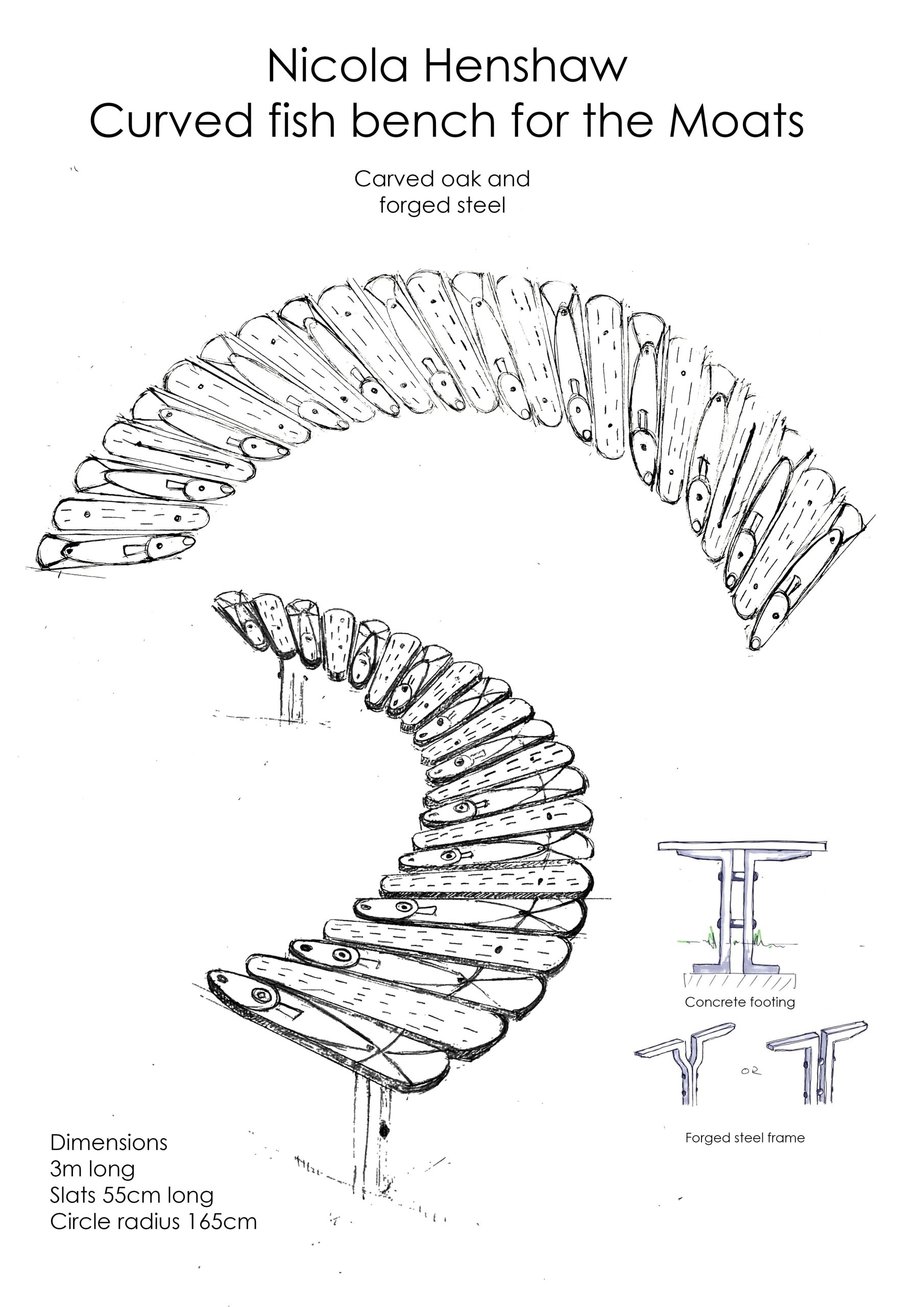
The bench is situated just outside the Cattle Market Car Park. Had you visited this location in the 15th century you would have found Baldington Manor, also known as Place House. This house was almost certainly the most important lay house in Thame during the Middle Ages, but was demolished in the 19th Century.
It is thought that Baldington Manor may have owned the fishponds known as ‘The Moats’ – stop 4 on our trail. This is because a field once known as Moats Close (now Barley Hill School field) adjoins both these grounds of Baldington Manor, and the Lea Park Moats. Read more at ThameHistory.net
Challenge Questions at The Fish Bench:
- How many fish can you find on the bench?
- What are the 2 names of the house that would have been found at this location in the 15th Century?
Continue the trail after Stop 2 – The Fish Bench:
- Carry on down North Street and turn right into the Cattle Market car park.
- Take great care walking straight through the car park to the other side where you will find a pathway.
- The railings that line this pathway are the next stop on the trail.
STOP 5: ‘The Moats’
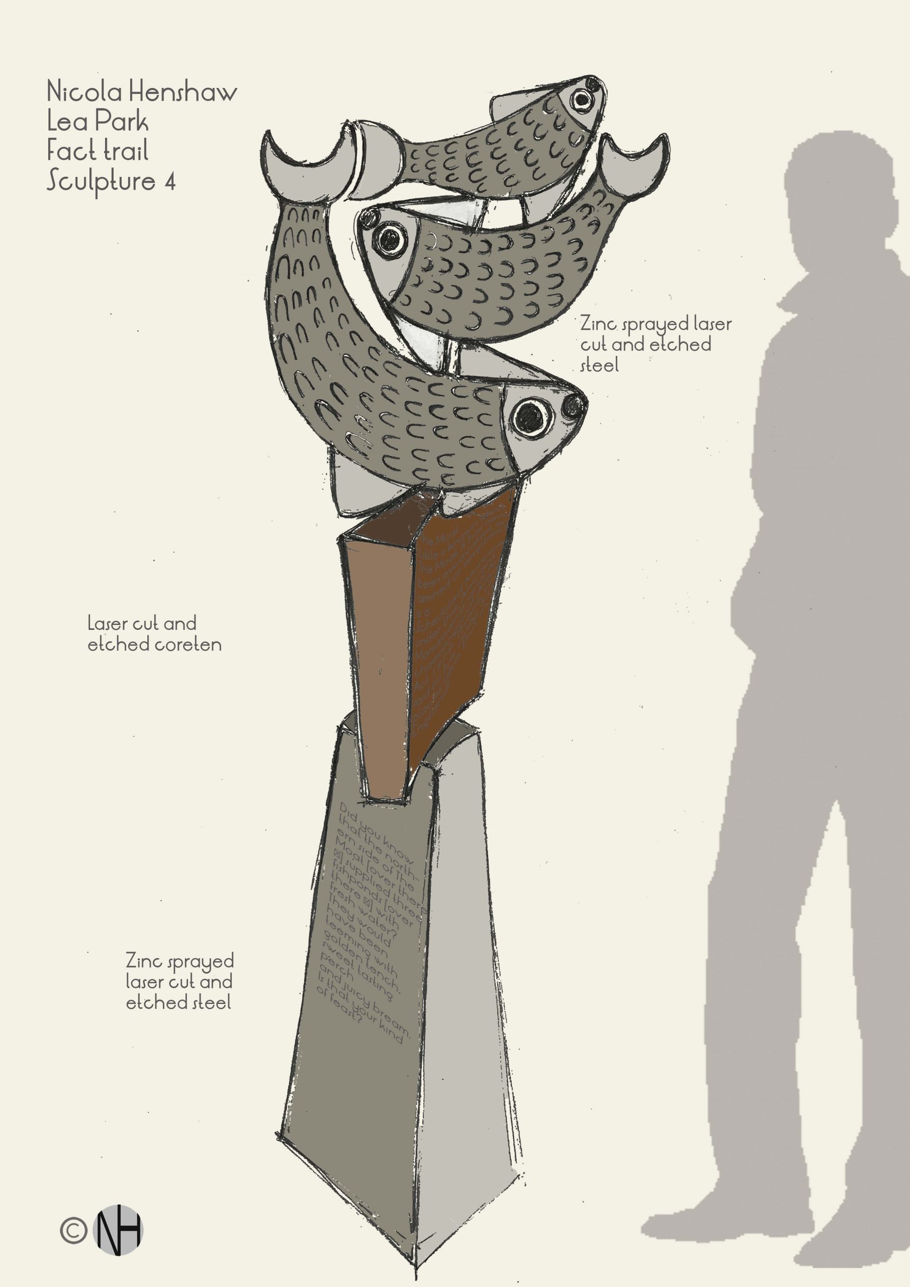
Read about this site on the piece of art that you can find at the corner of Denbigh Road and Cromwell Avenue.
Although this location doesn’t look like much, it could have served several different purposes over history.
 When Thame Town Council previously sought more information from Historic England their feedback noted that the Ordnance Survey map of 1880 shows a moat enclosing an island. From the features it suggests the moat could have originally been a medieval or post-medieval moated island containing a main house and outbuildings. This is a drawing they supplied to suggest what it may have looked like while in domestic use.
If this domestic use occurred, it would have been before The Moats became part of a Tudor garden, connected to Baldington Manor. The diagram you can see on the plaque shows the likely layout of the site, and you can read more about the excavation in an Article called ‘Three Fishponds at Thame, Oxon. 1973’, By R. A. CHAMBERS. Three Fishponds at Thame, Oxon. 1973 Credit to ‘The Oxfordshire Architectural and Historical Society’
A similar site was discovered in Quarrendon. Find out more about it here, where you can also see a drawing of what it might have looked like, providing a sense of what may have stood on the Cattle Market site and on The Moats site all those years ago. Another site where similar fish ponds have been discovered is at Woolstone (Milton Keynes).
Challenge Questions at The Moats:
- What year did R.A Chambers publish an article about The Moats?
- Looking at the piece of art: What can you find on the Baldington Family Crest?
Continue the trail after Stop 5 – The Moats:
- Walk up Denbigh Road towards the grounds of Barley Hill School.
- At the school fence turn left and walk through the alleyway to Henrietta Road.
- Carry on walking straight along Henrietta Road to pick up the footpath through to Ludlow Drive at the other end.
- Cross the road to the right to pick up a footpath that runs between Nos 13 & 15.
- Follow the footpath into Lenthall Green where you will find ‘Stop 6’ on our trail.